
服务热线: 4009966754 010-82654320,分机号:8003(销售)8004(技术)
发布时间:2024-05-22
Source of content *
Abstract
Taking the Wangdonggou Small basin in the Loess Tableland as the research object, combined with field sample collection and indoor and outdoor laboratory analysis, the spatio-temporal responses of soil water and stable hydrogen and oxygen isotopes of soil water (soil water was extracted by BJJL-2200 plant soil water extraction system) to the rainfall event were investigated under different land use modes. To provide scientific and technological support for the optimization of agricultural production pattern and ecological restoration in Loess Tableland.
conclusion
(1) Before and 7 days after the occurrence of this rainfall event (rainfall of 47.6mm), the average soil moisture content in the 0-3 m range of grassland, apple and corn fields was 16.13%±1.23%, 16.01%±1.38% and 16.53%±1.43%, respectively. The maximum response depth of soil water to the rainfall event was corn field, apple field and grass field in order from large to small, and the maximum response depth of the first two fields showed a phenomenon of decline after 2 days of rainfall infiltration. The vertical variation levels of soil water were divided into active zones, weak active zones and relatively stable zones by using ordered cluster analysis. The depth ranges of each layer in the barren grassland were 0~0.2, 0.2~0.4 and 0.4~3 m, respectively, and the depth ranges of each layer in the apple and corn fields were 0~0.2, 0.2~0.6 and 0.6~3 m. The initial depth of relative stability zone of soil water in wasteland is smaller than that in apple and corn fields.
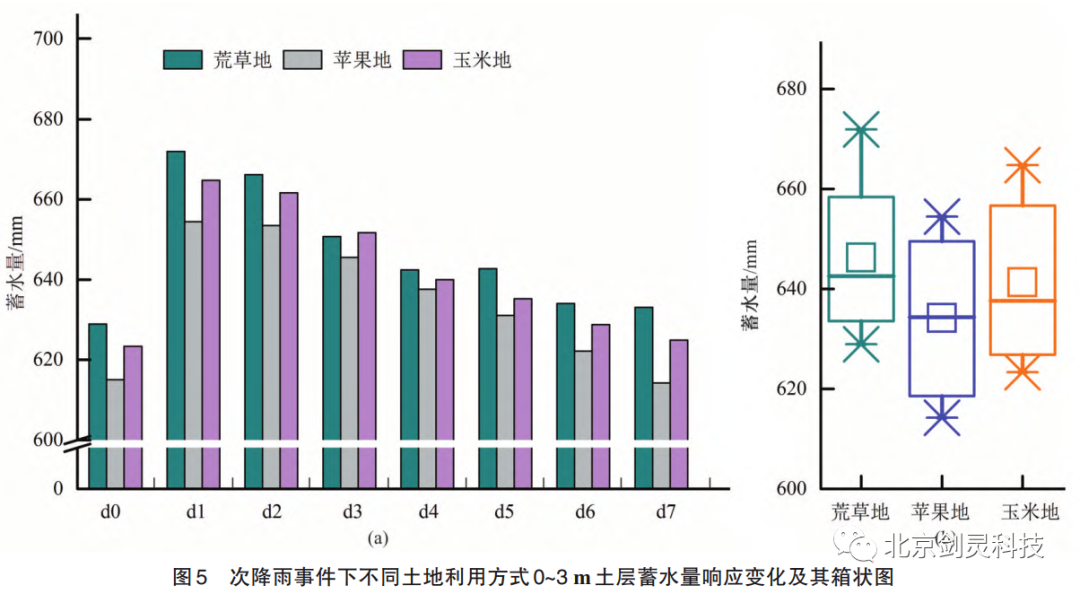
(2) Under the three land use modes, the water storage capacity of 0-3 m soil layer in descending order is wasteland, corn and apple, and the corresponding water storage capacity (depth of water storage per unit area) is 646.24, 641.29 and 634.19 mm, respectively. The average water storage capacity of each 20 cm soil layer is 43.25, 43.35 and 42.27 mm.
(3) Under this rainfall event, the δ2H and δ18O fractions of rain-water are -81.30‰ and -11.12‰; The δ2H of soil water in 0-3 m soil layers of grassland, apple and corn fields were (-63.91‰±13.55‰), (-65.60‰±14.60‰) and (-67.52‰±13.32‰). The delta 18 o average points don't + / - 1.77 ‰ (8.95 ‰), + / - 1.88 ‰ (9.13 ‰), + / - 1.90 ‰ (9.22 ‰).
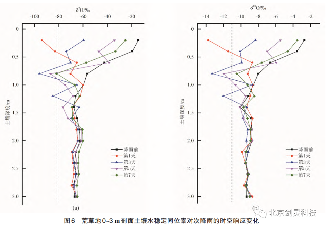
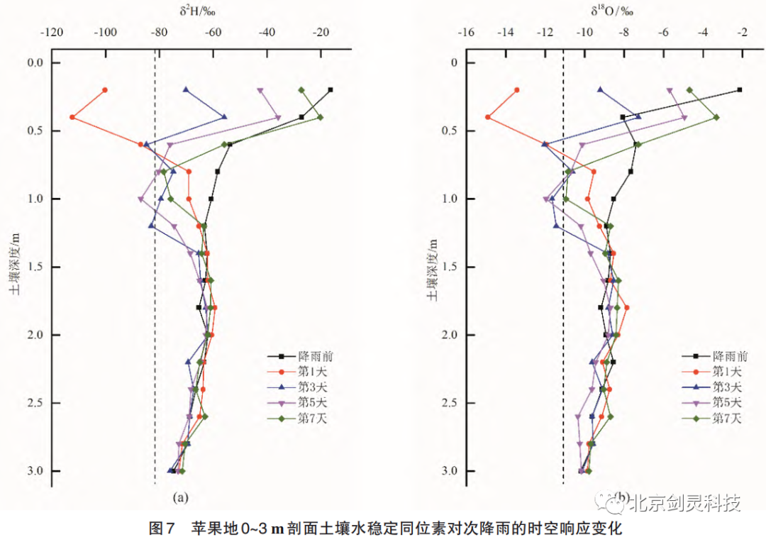
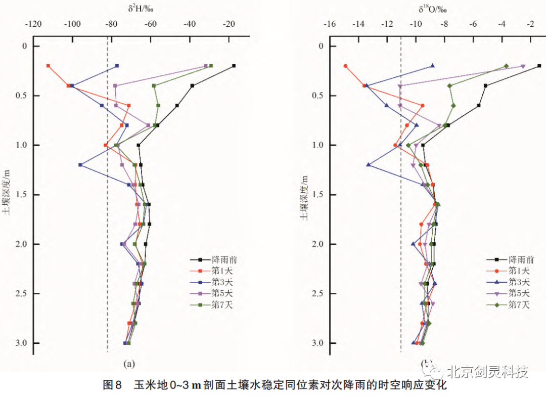
The surface soil water was depleted to different degrees under the influence of rainwater infiltration, and the infiltration capacity of the surface soil after rainfall was in the order of apple field, corn field, and barren grass field. The stable isotopes of hydrogen and oxygen in soil water showed a trend of "multi-peak" variation with depth within 3 m soil layer of the three land use modes. Rainwater infiltration under the three land use modes showed a process of alternating "piston flow" and "priority flow". After the flow pier, the flow velocity distribution tended to be uniform, and the bad flow pattern in the forepond was improved. After the flow rate is low, the rotation near the fork can be eliminated after development, the size of the rotation range is related to the length of the diversion pier and the fork Angle, so the "V" shaped diversion pier should not be too close to the inlet pool.


010-82654320,分机号:8003(销售)8004(技术)


4009966754
